|
|
Baltic Earth projects
A tentative compilation of current Baltic Earth projects is underway (latest on top). If you feel a project is missing, send an E-mail to the IBES. |
|
 BEAR and EN CLIME BEAR and EN CLIME
BEAR
BEAR (Baltic Earth Assessment Reports) is an activity to wrap together the currently available knowledge in the research fields of the Baltic Earth Grand Challenges plus some more. This will be done by teams of experts following the BACC principles, but not in a book format, but as a collection of review like papers in a special journal issue. The update of BACC II will be one of the BEAR papers.
EN CLIME
EN CLIME (Expert Network on Climate Change) is a group of experts in climate change issues in the Baltic Sea region, set up by HELCOM and Baltic Earth. With the help of EN CLIME, HELCOM will produce a comprehensive "fact sheet" on climate change and its impacts in the Baltic Sea region. There is a close collaboration between the climate related work on the BEAR and the production of the HELCOM climate fact sheet. |
|
SeaLaBio
Baltic+ Sea-Land Biogeochemical linkages (SeaLaBio)
https://www.syke.fi/projects/BalticSeaLaBio
The ESA funded project Baltic+ SeaLaBio will demonstrate the added value of Earth Observation for achieving the Baltic Earth “Grand Challenge 2” goals, and particularly, if combined with biogeochemical modeling. Colored dissolved organic matter (CDOM) is in the focus of this study. CDOM is part of the marine carbon cycle and the vast amount in the Baltic Sea is of terrestrial origin due to high CDOM concentrations in the northern rivers.
CDOM concentrations in the Baltic are high compared to open ocean waters. Therefore, standard algorithms do not work properly. In SeaLaBio, we will adapt remote sensing algorithms reflecting Baltic Sea conditions.
With the aid of a 3-dimensional ecosystem model of the Baltic Sea, we will show how modeling can benefit from Earth Observation data in particular with regard to calibration and validation, and providing flux data from land to coast.
For this project, we need to address scientific and technical issues along a processing and analysis chain:
- improved atmospheric correction of Sentinel 2 and Sentinel 3 data
- retrieval of water optical properties and water constituent concentrations
- exploiting synergistic and complementary use of Sentinel 3 and Sentinel 2
- retrieval of higher level products: eutrophication and sediment transport
- improve biogeochemical model calibration and validation
|
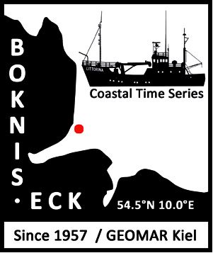
Boknis Eck Time-Series Station
https://www.bokniseck.de
Coordinator: Prof. Dr. Hermann W. Bange, GEOMAR, Kiel, Germany; +49-431-6004204, hbange@geomar.de
The Time-Series Station Boknis Eck is located at the north-eastern entrance of the Eckernförde Bay in the SW Baltic Sea. Boknis Eck belongs to the oldest -still operated- oceanic time-series stations worldwide: First regular hydrographic measurements (salinity) have been made on a daily basis in the Eckernförde Bay from 1876 to 1893. ‘Modern’ biological, chemical and physical measurements at Boknis Eck are conducted since 30 April 1957 on a monthly basis. The water depth at Boknis Eck is 28 m. Standards sampling depths are 1, 5, 10, 15, 20 und 25m. Salinity, temperature, phosphate and oxygen (O2) data have been recorded since 1957. Chlorophyll a measurements started in 1960. Additional nutrients (nitrate, nitrite, ammonium and silicate) and Secchi depths are available since 1979 and 1986, respectively.
Since riverine and groundwater inputs are negligible, the overall hydrographic setting at Boknis Eck is dominated by the regular inflow of North Sea water through the Kattegat and the Great Belt. Seasonal stratification occurs usually from mid-March until mid-September and causes pronounced hypoxia (O2 < 10 µmol L-1) which sporadically become anoxic. To this end, the location of Boknis Eck is ideal to study (i) a coastal ecosystem under the influence of pronounced changes of salinity and (ii) biogeochemical processes sensitive to changes of dissolved oxygen.
A cabled underwater observatory for high resolution online measurements (incl. temperature, salinity, ADCP, O2, CO2, and CH4) has been installed in December 2016 at 14.5 m water depth in close vicinity to the monthly time-series site. The complimentary online measurements will help to improve our ability to capture short-term events such as upwelling etc. at Boknis Eck.
Further information about Boknis Eck is available under www.bokniseck.de . |
 BloomSail – Research Expedition Gotland Sea 2018 BloomSail – Research Expedition Gotland Sea 2018
Chasing cyanobacterial blooms with a small sailboat (Jens Müller, Leibniz Institute for Baltic Sea Research Warnemünde, Germany)
Cyanobacteria (aka blue-green algae) blooms contribute to the biggest problems in the Baltic Sea: eutrophication and oxygen depletion. We can roughly judge the size of the blooms through satellite imaging and automated CO2 measurements on voluntary observing ships, but only see what happens on the surface of the water. Ordinary research vessels are expensive and inflexible, making it difficult to investigate these sporadic and short-lasting blooms. Reasons for the formation of the algal blooms, and knowledge of what happens in the deeper water levels remain a mystery. In the summer of 2018, Jens Müller will set sail for a four month expedition with his sailboat Tina V. He’ll be there with his crew, ready when the drama begins, to study the blooms with precise CO2 measurements.
BloomSail website... |
BONUS INTEGRAL
Integrated carbon and trace gas monitoring for the Baltic Sea
A BONUS project, duration 3 years (2017-2020)
 BONUS INTEGRAL seeks to demonstrate and exploit the potential added value of the marine stations of ICOS and similar instrumentation for the ecosystem state monitoring of the Baltic Sea as an important contribution to a state-of-the-art improved HELCOM monitoring. BONUS INTEGRAL seeks to demonstrate and exploit the potential added value of the marine stations of ICOS and similar instrumentation for the ecosystem state monitoring of the Baltic Sea as an important contribution to a state-of-the-art improved HELCOM monitoring.
Currently, twelve European nations are national partners of the Integrated Carbon Observation System (ICOS), the pan-European research infrastructure (RI) to provide high-precision data on Greenhouse Gas fluxes and budgets. Four of the pan-Baltic countries (Finland, Sweden, Germany, Denmark) are already partners in the ICOS RI with partly or fully established infrastructure, other countries like Poland and Estonia are currently in the process of developing their strategy towards ICOS. The overall aim of ICOS with its large investments is to provide European-wide CO2 and – to a lesser extent – non-CO2 (i.e. methane and nitrous oxide) greenhouse gas concentration and flux data.
BONUS INTEGRAL seeks to demonstrate and exploit the potential added value of the marine stations of ICOS and similar instrumentation for the ecosystem state monitoring of the Baltic Sea as an important contribution to a state-of-the-art improved HELCOM monitoring. In direct response to the requirements of the European Marine Strategy Framework Directive, BONUS INTEGRAL will provide new approaches for the monitoring of marine eutrophication and acidification, and explore the integrated greenhouse gas flux as a potential new indicator for the good environmental status of the Baltic Sea.
Integrating the different components and data streams of ICOS, related infrastructure, and pre-existing related data in the pan-Baltic Sea area will be in the core of BONUS INTEGRAL. Field studies will be conducted to assure operation and install amendments to existing infrastructure in maximizing innovation and gained knowledge. One major aim of the project is to provide best possible experimentally based seasonal surface concentration charts of carbon dioxide, methane and nitrous oxide over the Baltic Sea.
Within BONUS INTEGRAL, the carbon system implementation in an existing high resolution, physical-biogeochemical model will be scrutinised and improved, and the model results will be evaluated against observations of the carbon system (and other variables). This approach is based on the strong, scientifically underpinned belief that the cycling of carbon is the key variable of marine biogeochemistry, is linking the effects of eutrophication and deoxygenation, and determines the magnitude of coastal acidification.
In order to strengthen the Baltic Sea ecosystem monitoring, the project will advise the implementation of ICOS in the south-eastern countries of the Baltic, and actively promote the implementation of an ocean (sea) component. The aim is also to demonstrate the added value of using greenhouse gas data in combination with carbon system data, and promote project’s findings towards a better, cost effective ecosystem based monitoring of the Baltic Sea.
Gregor Rehder, Leibniz Institute for Baltic Sea Research Warnemünde, Project Coordinator
BONUS page of this project |
Wellbeing from the Baltic Sea – applications combining natural science and economics
A BONUS project, duration 3 years (2015-2018)
The project will study both the supply and demand of marine ecosystem services across the entire Baltic Sea region in a spatially and temporally detailed manner. The first key objective is to identify long-term strategies for safeguarding a sustained supply of ecosystem services that support sea-dependent lifestyles and wellbeing in the Baltic Sea region under anticipated climate and socio-economic developments. This is achieved by a novel combination of existing state-of-the-art modelling tools and recently collected data to link anthropogenic pressures, marine ecosystem and human wellbeing. The second key objective is to utilize the concept of ‘Citizen Science’ and recent developments in information technology to experiment innovative, low-cost methods to acquire spatially and temporally detailed data on the demand of cultural ecosystem services. For this end, we apply a soft-GIS application for valuation of cultural ecosystem services and pilot a mobile application that enables the end-users of the Baltic Sea ecosystem services share spatially and temporally explicit information on the state of the Baltic Sea. These applications provide the research community and policymakers valuable information on the consumption patterns and hotspot areas of recreation and other cultural ecosystem services, and fill in knowledge gaps related to those ecosystem services that are particularly important for well-being.
Read the article by Kari Hyytiäinen, University of Helsinki in the Baltic Earth Newsletter 3 (June 2017) |
.jpg)
Sustainable shipping and environment of the Baltic Sea region
A BONUS project, duration 3 years (2015-2018)
SHEBA will analyse the drivers for shipping, obtain the present and future traffic volumes and calculate a set of scenarios which will then feed into calculations of emissions to water, to air, and of underwater noise using and extending the currently most advanced emission model based on Automatic Identification System (AIS) ship movement data. Atmospheric, oceanic and noise propagation models in combination with ecotoxicology studies will then be used to assess spatio-temporal distributions, fates and effects of these stressors in the Baltic Sea region. The project will assess the impact of different pollutants to the water quality indicators of the Marine Strategy Framework Directive and Water Framework Directive and to the air quality indicators. Further, the project will provide an integrated assessment of policy options to mitigate pressures linked to shipping, quantifying as far as possible anticipated changes in ecosystem services compared to an established baseline. This will include an analysis of trade-offs between options as well as synergies, and the marginal changes in costs and benefits of options to reduce environmental pressures from shipping and support the achievement of Good Environmental Status as prescribed by the Marine Strategy Framework Directive. SHEBA is supported by a wide group of stakeholders, including harbours, shipping industry and authorities, who will be consulted about the input of data, feedback and results of the project.
Read the articleby Markus Quante (Helmholtz-Zentrum Geesthacht, Insititute of Coastal Research, Geesthacht, Germany) and Jana Moldanova (Swedish Environmental Research Institute (IVL), Gothenburg, Sweden) in the Baltic Earth Newsletter 3 (June 2017) |
Local spatial and temporal variability of meteorological characteristics in cold period over the Western Dvina basin
(Dr. Lev Kitaev et al., Institute of Geography RAS, Moscow, Russia) |
If you are involved in any of the Baltic Earth related Grand Challenges, you are encouraged to send us a project proposal. Details |
|
BALTEX Projects
BALTEX Phase II projects
Large interdisciplinary projects
- PolPer:Baltic2011 - A survey of political stakeholders’ perceptions of climate change and adaptation in the Baltic Sea region
- BACC II - Second BALTEX Assessment of Climate Change in the Baltic Sea Basin (Hans von Storch and the BACC II Group)
- Baltic-C - Building predictive capability regarding the Baltic Sea organic/inorganic carbon and oxygen systems (A BONUS funded project; coordinator: Anders Omstedt, University of Gothenburg)
- ECOSUPPORT - Advanced tool for scenarios of the Baltic Sea ECOsystem to SUPPORT decision making (A BONUS funded project; coordinator: H.E. Markus Meier, SMHI)
- AMBER - Assessment and Modelling of Baltic Ecosystem Response
- BACC - BALTEX Assessment of Climate Change in the Baltic Sea Basin (Hans von Storch and the BACC Group)
- BALTIC GRID - BALTEX II Major Data Analysis and Networking (Andreas Lehmann)
- HYACINTS - HYdrological Modelling for Assessing Climate Change Impacts at differeNT Scales (Danish National Research Project, various partners)
Individual research projects
- Sea ice physics in the
Baltic Sea
-
Jari Haapala, Timo Vihma, Bin Cheng, Markku Similä, Juha Karvonen, Roberta Pirazzini, Eero Rinne, others are welcome
- Coastal Meteorology in the
Northern Baltic Sea
-
Hannu Savijärvi, Timo Vihma, Sami Niemelä, Lorenzo Claveri, Priit Tisler, others are welcome
- Modelling the deposition of persistent organic pollutants into the
Baltic Sea
at long time scales - Armin Aulinger, Volker Matthias, Markus Quante
- ICTS (Inter-CSE Transferability Study) - Burkhardt Rockel and others
PhD projects in work
Finished Ph.D. projects (with links to full thesis downloads)
|
BALTEX Phase I projects
|
BALTEX Phase I Field Campaigns
Three major field campaigns including related modelling and analysis activities with funding support through both the 4th and 5th European Framework Programmes have been conducted by members of the BALTEX community:
- BASIS - The Baltic Air-Sea-Ice Study
- CLIWA-NET - BALTEX Cloud Liquid Water Network
- PEP in BALTEX - Pilot Study of Evaporation and Precipitation over the Baltic Sea
|
|
|